Other Engineering Page 12
Other Engineering

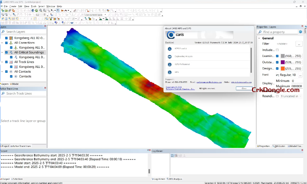
CARIS HIPS&SIPS Multi-beam Side Scan Sonar Post-processing Software CARIS HIPS and SIPS is a comprehensive hydrographic processing software suite. For over a decade, CARIS HIPS and SIPS have been leading software in the field of marine hydrographic processing and surveying, capable of meeting most surveying needs. Regardless of the application, its reliability and practicality remain absolutely stable when processing data from echo sounders and side scan sonars. Generally, you can choose CARIS HIPS to process large-scale bathymetric data and CARIS SIPS to process side scan sonar and multibeam-acquired image data. Key Features and Improvements in HIPS and SIPS 12.1.0 Subset Corrections Enhancements: Introduces a new Automatic-Corrections feature for faster and more versatile processing. Updated Subset Corrections with tabs for manual...
VirtualLab Fusion The Multiscale Optical Simulation and Design Platform VirtualLab Fusion is a unique optical design software designed for multiscale optics simulations. It integrates a wide range of simulation models for all types of optical components, both large and small, seamlessly combining them on a single software platform. With its ability to use the most appropriate solver for each component, VirtualLab Fusion ensures fast simulations while continuously tracking the full electromagnetic field and accurately accounting for diffraction and interference effects. Components such as nanostructures, metalenses, gratings, mirrors, and lenses, along with their simulation models, are fully integrated into one user-friendly interface. Thanks to its non-sequential methodology, VirtualLab Fusion simplifies even the most complex optical design tasks, making it the ideal choice...
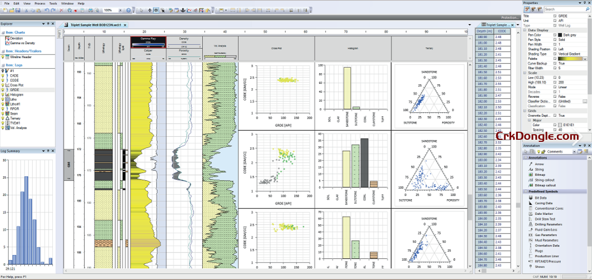
WellCAD 5.8 is a Windows-based software by Advanced Logic Technology (ALT) for processing and visualizing borehole geophysical and geological data, widely used in mining, oil and gas, and geotechnical industries. Key features include: New Features: Enhanced fracture topology analysis, integrated header editor (replacing standalone HeadCAD), new chart types (e.g., pie charts, improved Rose diagrams), advanced depth matcher with undo/redo/reset, and improved S-wave picking with kurtosis-based algorithms. Visualization: Supports dynamic charts, hyperlinks in headers, and displays for logs, curves, images, and statistical diagrams (e.g., polar, cross-plots). Data Handling: Imports ASCII, Excel, LAS, and image files (BMP, TIF, JPG, PNG); offers depth management (measured depth, TVD, time); and includes tools for data editing, filtering, and interpolation.
GEOVIA Surpac 2025 provides mining companies with the powerful, reliable, and customizable 3D mine planning and geological modelling software they need to deliver advanced drillhole-data management, perform rigorous statistical and geostatistical analyses, and develop comprehensive resource models, mine designs, and mine plans for either open pit or underground operations. With Surpac, geologists can quantify and evaluate the physical characteristics of a deposit, even with limited information. Engineers can visualize mine designs and plans that maximize ore recovery while complying with project constraints. Mine production teams can integrate vast amounts of data to determine the best way to extract reserves. GEOVIA Block Modeler Analyze the spatial variability of earth characteristics and create regularized volumetric models of the combined set of characteristics....
PVsyst 8.0.13_Design and simulation software Define your project System design: Rapidly design grid-connected, standalone, or pumping photovoltaic systems. The program guides you in selecting components for sizing your project. System sizing: Visualize sizing constraints for modules and inverters, including I/V curves and power distribution, focusing on optimal inverter sizing and comprehensive loss analysis. New orientations: Benefit from flexibility in project customization by defining unlimited orientations and explore the possibility of combining trackers and fixed plans in a single simulation. Simulation and results: Calculate annual energy distribution, analyse key metrics such as total energy, yield, and specific energy, through detailed reports on gains and losses. Near shadings: Model your 3D scene directly or import it from another CAD tool. Fast design...
Leica HxMap 4.7.1, high-performance post-processing workflow for airborne sensor data, features intuitive interface and industry’s fastest data throughput. The increased need for up-to-date geospatial information in many of the traditional applications as well as in emerging areas such as navigation or location-based apps requires a new approach to data processing: rapid updates over large areas in the shortest possible time. To be a true No 1, the world’s most efficient airborne sensors still rely on an efficient and fast data processing workflow. By introducing HxMap, the unified high-performance multi-sensor workflow platform, Leica Geosystems offers exactly what the industry has been waiting for: a fast, intuitive and efficient post-processing platform, that allows you to produce all known data products within one single interface. The Leica HxMap 4.7.1 common sensor post-processing platform offers the following modules to meet...
Leapfrog Geo 2025_3D modelling and visualisation for mining Build well-informed and dynamically updatable geological models in a fraction of the time. Bypass time-consuming wireframing and rapidly generate, visualise, and maintain 3D implicit models that maximise the value your data. Accelerate geological modelling Implicit modelling lets you build geological models faster and more intuitively with workflows designed for geologists. Build more robust models Collate and integrate all your geoscience data, including drillhole data, structural data, points, polylines, and meshes, to generate reliable models and make informed decisions. Visualise and explain complexity Easily build and share 3D models that visually communicate complex information to stakeholders. Effortlessly update models with new data Effortlessly update models with new data Leapfrog Geo 2025 Dynamically update...
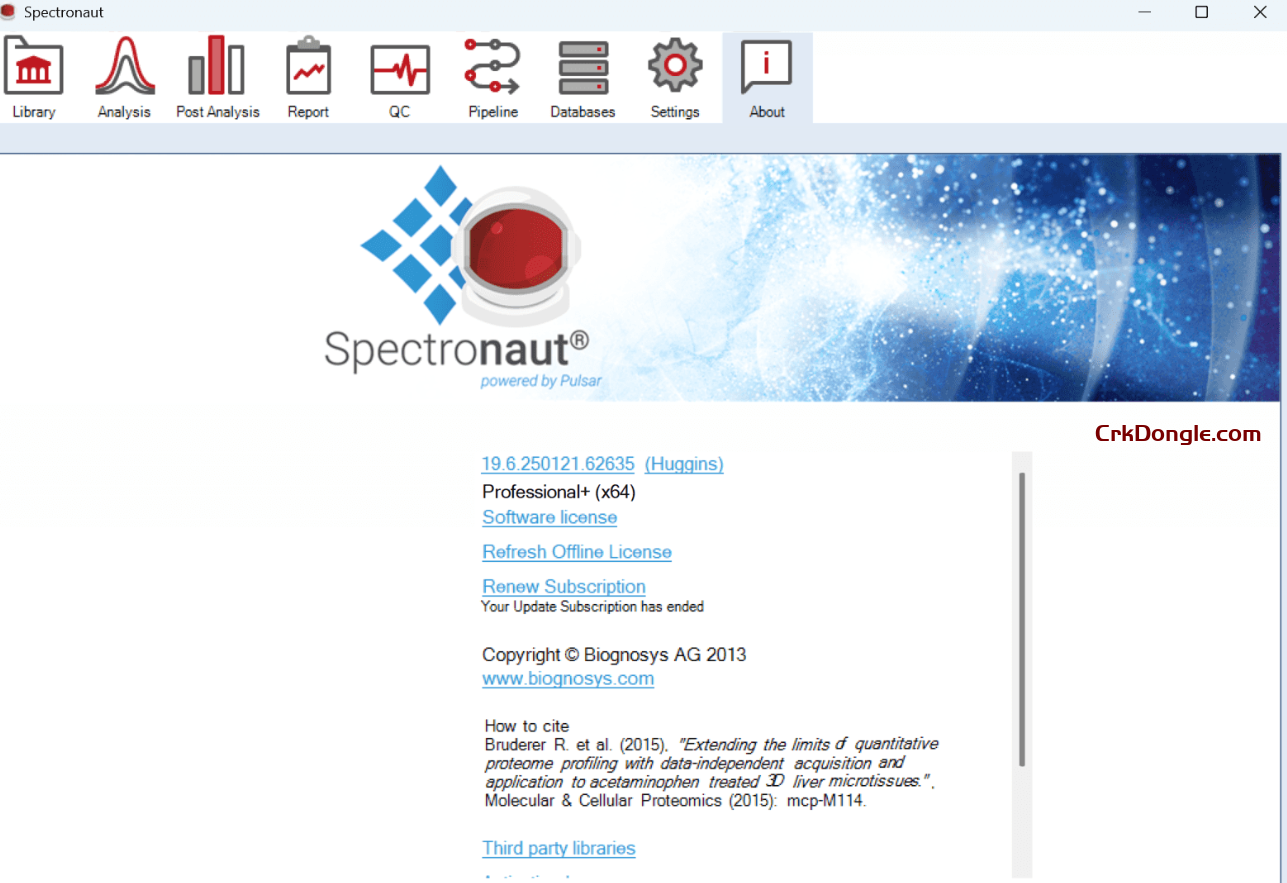
Spectronaut 20 is a powerful software package developed by Biognosys for analyzing data-independent acquisition (DIA) proteomics experiments. It is designed to deliver high-performance analysis with enhanced speed, depth, and scalability, particularly for complex proteomic datasets. Below is an overview based on available information: Key Features of Spectronaut 20: Kuiper Search Engine: Introduces a new search engine that significantly boosts speed and depth, achieving ~70% faster runtimes and ~75% more HLA class I peptide identifications compared to Spectronaut 19. It excels in complex search spaces like unspecific digests and PTM (post-translational modification) discovery. directDIA Workflow: Streamlines immunopeptidomics by outperforming library-based approaches, identifying ~40% more HLA type I peptides on average. This eliminates the need for extensive spectral library creation, saving time...
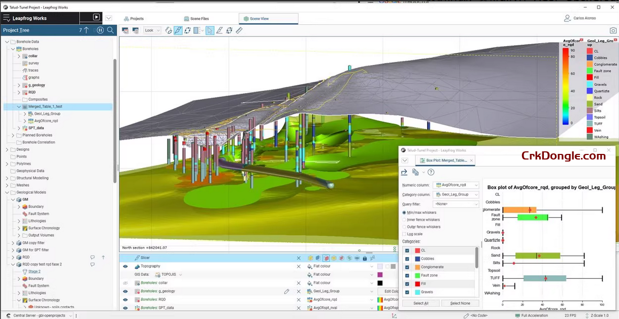
Leapfrog Works 2025 is a 3D geological modeling software developed by Seequent, specifically designed for civil engineering, environmental projects, and groundwater management. It helps users make more informed decisions in infrastructure construction, environmental assessment, and geological risk management. The following is a brief introduction to Leapfrog Works 2025: Core Features and Benefits 1 Dynamic 3D Geological Modeling: • Utilizes FastRBF™ (Fast Radial Basis Functions) technology to quickly build 3D geological models from borehole data, geophysical data, historical maps, and cross-sections, reducing manual modeling time. • Supports dynamic updates, so when new data is input, the model and outputs (such as cross-sections) automatically update without the need for reconstruction, saving time and costs. 2 Multi-disciplinary Data Integration: • Supports multiple industry-standard...
Leica Infinity v4.3 , intuitive office software from Leica Geosystems, has replaced Leica Geo Office . Today’s surveying requires the ability to flexibly and quickly process field data and office information anywhere and transfer it. Now more than ever, there is a need for a unified workflow for all projects. Leica Infinity was developed to meet this need: a user-friendly, intelligent software platform with an intelligent information architecture that opens up unlimited possibilities for workflow organization. The result is increased efficiency, transparency, and overall improvement of the entire surveying process. The program has the following optional modules and features: – Processing of total station data – Leveling processing with height adjustment capability – 3D adjustment – Working with surfaces –...
AMCAD, a leading innovator in microwave component measurement and design solutions, has developed IQSTAR—a groundbreaking software solution that addresses the complex challenges faced by companies in the production testing of RF/microwave components and circuits. In collaboration with strategic partner Maury Microwave, AMCAD offers a comprehensive suite of services and solutions, ensuring optimal design performance and reducing time-to-market for clients. The demand to bring cutting-edge developments to market quickly, while demonstrating the superior quality of products, has posed a significant challenge for many companies. Furthermore, customers are increasingly seeking detailed application-specific data beyond traditional small-signal measurements and frequency swept S-parameters. To address these evolving needs, AMCAD Engineering has developed IQSTAR. This turnkey software solution features a versatile and customizable schematic editor...
PICS3D, Photonic Integrated Circuit Simulator in 3D, is a state of the art 3D-simulator for surface and edge emission laser diodes, SOA, and other similar active waveguide devices. The 2D/3D semiconductor equations (drift-diffusion, Poisson, etc..) are coupled to the optical modes in both lateral and longitudinal directions. Optical properties such as quantum well/wire/dot optical gain and spontaneous emission rates are computed self-consistently. Starting from the 2016 version, the functionality of our 2D laser solver (LASTIP) has also been folded into PICS3D: this allows for easy simulation of laser devices without significant longitudinal effects and more flexibility for customers working on a variety of laser device designs. Physical model – Deep level defects and defect dynamics – AC analysis model –...
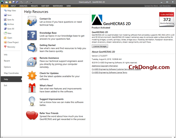
CivilGEO GeoHECRAS , developed by CivilGEO, is a civil engineering software that enhances the U.S. Army Corps of Engineers’ HEC-RAS program with an interactive 2D/3D graphical user interface. Released on July 7, 2022, it integrates with AutoCAD, Bentley MicroStation, and ESRI ArcGIS, streamlining workflows for hydraulic modeling, floodplain mapping, and infrastructure design. Key features include: Enhanced Modeling: Supports 1D and 2D steady and unsteady flow computations, bridge and culvert design, flood inundation mapping, and river restoration. It pulls data from various sources like CAD files, GIS data, and digital elevation models (DEMs) for rapid HEC-RAS model creation. Visualization: Offers 2D/3D visualization with georeferenced maps (e.g., Google Maps, Bing Maps), allowing users to layer FEMA flood maps or export to Google...
HxGN MinePlan 2024 is a comprehensive mine planning software suite developed by Hexagon’s Mining division, designed to support geologists and engineers in creating detailed 3D geological models and optimizing mine operations from exploration to production. Below is an overview of its key features, updates, and enhancements based on the latest available information: Key Features of HxGN MinePlan 2024 Block Model Manager 2.0 (Release 2, 2024): Enhanced Security and Control: Introduces an identity management module integrated with Windows user accounts, streamlining access permissions based on roles to ensure only authorized users can view or modify block models. Audit Trail and Version Control: Allows tracking of changes to block models, enabling users to trace errors and revert to previous versions for greater...
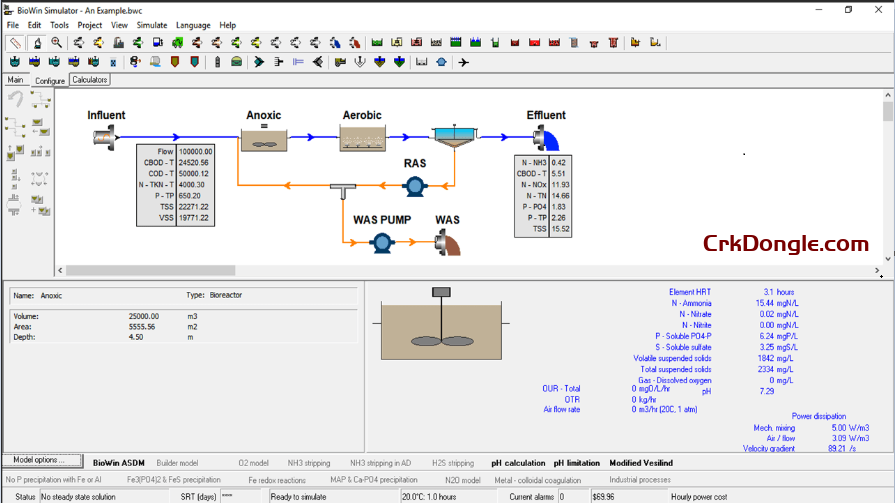
BioWin 6.3: Advanced Wastewater Treatment Simulation Software Overview BioWin 6.3, developed by EnviroSim, is a premier wastewater treatment process simulator used globally for designing, analyzing, and optimizing wastewater treatment plants (WWTPs). This Microsoft Windows-based software integrates biological, chemical, and physical process models to deliver comprehensive plant-wide simulations, ensuring cost-effective designs and regulatory compliance. Key Features Advanced Biological Modeling: Simulates microbial activity, nutrient removal, and EBPR with precise influent VFA characterization. Chemical and Physical Processes: Models pH, oxygen transfer, and gas-liquid interactions with new precipitate variables (calcium carbonate, calcium hydroxide, magnesium hydroxide). Enhanced MBR and N2O Modeling: Includes flat plate MBR elements and advanced nitrous oxide modeling with N2O reduction. User-Friendly Design: Features updated flowsheet visuals, customizable settings, and pre-configured layouts...
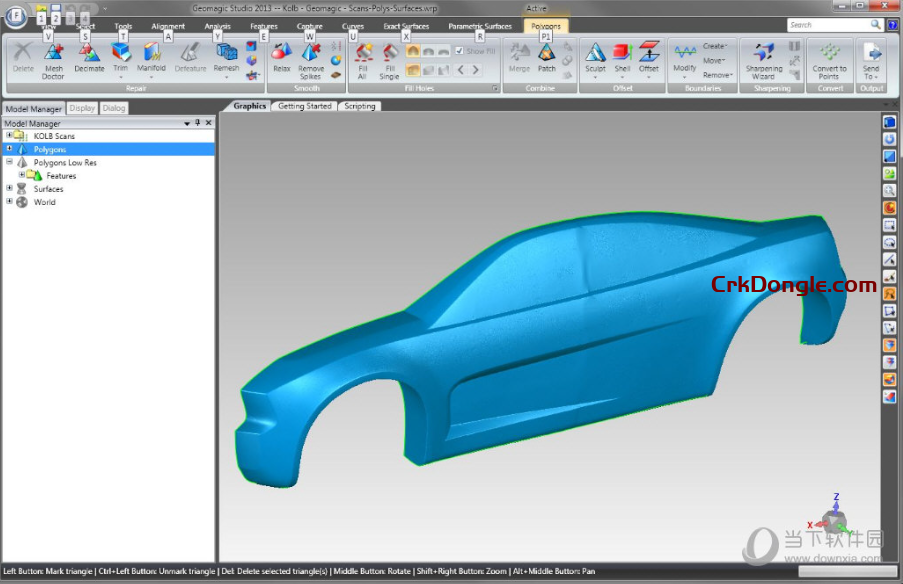
Geomagic Wrap provides the easiest-to-use, affordable, fastest and most accurate way to go from point clouds to 3D polygonal models. Geomagic Wrap 2024 crack download allows you to convert point cloud and sensor data into 3D polygon meshes for use in manufacturing, engineering, entertainment, archaeology, and analysis. Intelligent, automated and flexible, Geomagic Wrap provides best practice and highest quality 3D data from scan data with high accuracy and productivity. – Very fast creation of 3D models for further uses such as 3D printing, archiving and transfer to visual effects, rendering and for application in other systems. – Improved editing, navigation and visualization of point clouds derived from mid-range and long-range scanners to create real three-dimensional models improves data understanding and...